
Lessons from the end of the world
I’ve made a career out of taking piles of complex information (like financial markets) and turning it into useful stories people care about and can use. What a failure I would be if I couldn’t do the same with six weeks of Antarctic travel. Especially because Antarctica poses the same challenge as financial markets—it’s so vast, people have their own constraints (specific itineraries, time limits), and everyone’s at a different stage of their journey—literally, in this case.
So, I’m organizing this into: Things to know beforehand, places we went, and making the most of things when you’re there. Let’s get into it.
What to know before you go to Antarctica
Antarctica is breathtaking
I never had any interest in going to Antarctica. Most of the photos showed grey skies and penguin poop, and I wasn’t all that interested in penguins. I cannot begin to explain how misguided that impression was.
Since there’s no single “thing” about Antarctica—no iconic photo that everyone wants, it can be hard to search destinations ahead of time or scope out what to expect. Since we got to plan our own itinerary, I spent time poking around various destinations on google and saw… a lot of kind of dirty snow. So let me dispel that for you early.
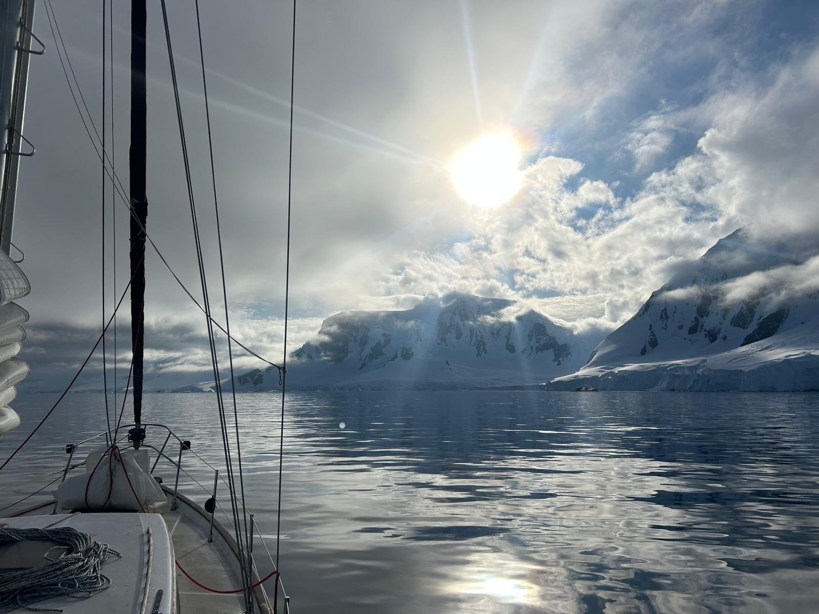


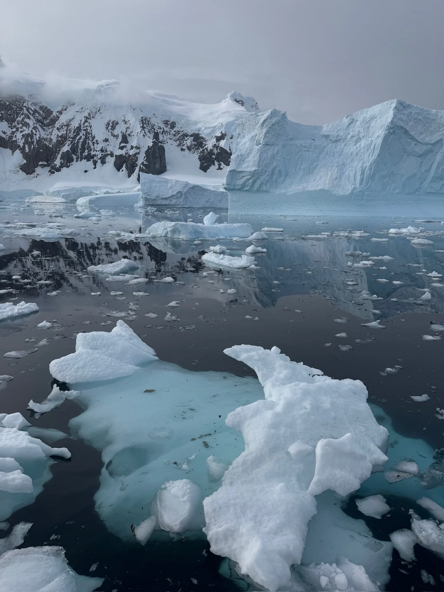
While the weather can be unpredictable (and windy grey days are… not fun and can last for three days), the sun always comes out and that is SPECTACULAR. Usually the windy chaos brings fresh ice cleaving, meaning new icebergs floating on lake-calm seas and passages. The calm water offers perfect reflections of what’s above it. The landscape is craggy mountains totally covered in glaciers, the scope of which is impossible to capture in photos. It’s made all the more beautiful when you realize that no one will ever have that view again. The ice will melt, a storm will hit, and more than any other landscape on earth… everything about it will be different in a week.
A note on weather
Antarctica is big. And because it’s on the bottom of the globe, and there’s no cities or permanent settlements there, it’s not accurately represented on most maps. Good luck trying to find a weather forecast. Most tourist trips to Antarctica leave from South America and head to the area around the Graham peninsula in the Western Hemisphere. If you meet folks who are headed to research bases (particularly McMurdo, which is the largest U.S. base, and a favorite for 20-somethings looking for cool winter jobs) those might be in totally different parts of the continent. And while most things on Antarctica are… icy and cold… there’s different geographic phenomenon, different penguins, different… stuff… depending on where you are. I’ve only done the Patagonia trip, so that’s what I’ll focus on.


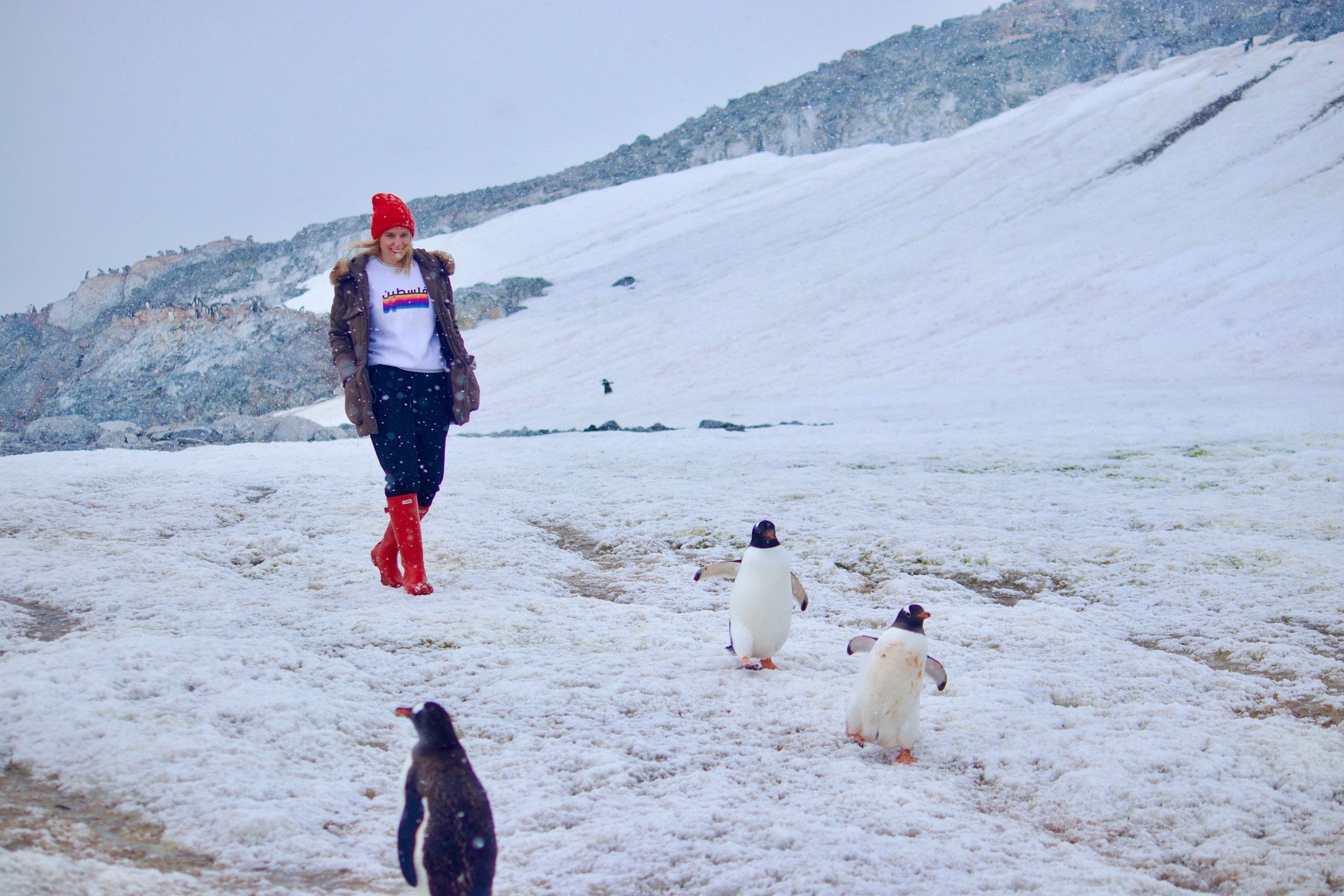
With that in mind… It’s not that cold in Antarctica during the summer. It *is* that cold in the wind and on the ocean. The temperature most days was ~34° or so. Which… is warmer than most winter days in Chicago. It gets cold when you’re sailing because of the wind and the damp. And the polar winds? Those are cold. But on a sunny day when there isn’t much wind? That pure southern sun can warm you up to a “feels like 60s” kind of day. I stripped down to a tank top for hiking and walking around on two separate occasions. I wouldn’t plan for that, but I also wouldn’t live in fear of the cold. Most cruises will provide gear. I didn’t buy anything all that special. I WOULD strongly suggest base layers, like fleece-lined leggings, and very warm wool socks and gloves. As you can see in the photos above, we did a lot of layering… Cold feet, cold hands, and cold head are probably your biggest considerations.
Plan outfits + souvenirs
Antarctica may be the coolest place you ever go, so plan accordingly. If you have something big to announce (work or personal) plan to take the photos there. Are you ever going to get another chance to take a photo of you in a penguin sweater standing next to penguins? Probably not. There’s no better way to tell your friends you love them than by wearing their company sweatshirt in Antarctica, reading their book in a penguin colony, or… you get the drift.


There’s no real way to buy souvenirs (unless the cruise ship sells them or you want to spend a lot in either Port Lockroy or the Falklands where options are limited and rarely local). My recommendation is to buy small things and take them with you, then photograph them in cool places. It will mean the world to people, but it requires you to plan ahead. I didn’t want to spend a ton of money on postcards, so I drew one, ordered 100 ahead of time on VistaPrint, wrote the notes on the Drake… and ended up with many very happy friends, family, and clients. It wasn’t hard, it just required planning ahead.
A note on geography
For Americans who grew up learning about swashbuckling explorers who sailed the globe, discovered the earth was round, and ended up with scurvy… Cape Horn and the Strait of Magellan can sound like mystical places. So, here’s a reality check on the geography. You’ll leave for Antarctica from Patagonia, which is the southern glacial region of South America—it includes both Chile and Argentina.
Most cruises and sailboat rides leave from either Ushuaia (Argentina) or Puerto Williams (Chile), which are on the Beagle Channel. The Beagle Channel separates the mainland of South America from Tierra del Fuego (land of fire) an archipelago made famous by Charles Darwin among others. To get to Puerto Williams (which is where I left from) you go through Punta Arenas, which is on the Strait of Magellan. This is another route from the Atlantic to the Pacific that’s further north than the Beagle Channel, and thus was a favorite for old school sailors looking to shave time off their trip before the Panama Canal was completed. Cape Horn is an actual island—the southern most point in South America—and it’s not as easy to spot or as exciting as you might think. (We’re pointing at it in the photo below.) Chile tends to be cheaper than Argentina for flights and the Santiago airport is a bit less chaotic, from what I hear, than Buenos Aires, but it all depends on what you’re looking for and what else you’re doing.


If your trip gives you the option to stop at the Falkland Islands… just know that it’s the closest you will ever get to time travel, and the 1990s are a lot less fun when you already know how Britney Spears turned out. (More on that later…)
The lingo… Arctic, Antarctic, Polar… and more
First things first: The Artic is the north pole. The south pole is Antarctic. Annoyingly longer to say, but… alas. Both regions have polar elements (meaning near to the pole, but also meaning, by default, cold.) Technically, you are in the polar circle whenever you get past 66°33’ north or south. We only got to about 64° on our trip, so no polar circle (at least not this time). If a cruise advertises it will take you to the polar circle, or the Antarctic circle, it means they plan to cross that latitude. This is where you’ll get true 24-hour sunlight (or darkness) during the summer/winter… but we never saw a sunset even at 64°.
You don’t need to cross the Antarctic circle to be in Antarctica. Once you cross the 60th parallel (or 60°), you’re in Antarctica. That’s when the Antarctic Treaty System kicks in… meaning your boat needs to be permitted, there’s no official government, and you’re subject to certain rules around protection and conservation. It’s also affectionately known in maritime circles as the “screaming sixties” since the combination of water patterns and polar winds can be so brutal. Compare that to the “furious fifties” and the “roaring forties” and you start to realize that sailors have a healthy respect for the Southern (and surrounding) Oceans.
Fun fact: If you leave from the Beagle Channel and sail around Cape Horn, you’ll technically hit three oceans—the (south) Pacific in the Channel, the (southern) Atlantic when you exit and the Southern Ocean once you enter the Drake/Antarctica.
The Drake Passage
It’s known as one of the gnarliest stretches of ocean on the planet for good reason. In a nutshell: Currents from basically all of the world’s oceans collide in the Southern Ocean, and the distance between the southern tip of the Americas and the north tip of the Graham Peninsula is only about 400 miles (much narrower than, say, the southern tip of Africa to mainland Antarctica). So all of those currents are shoved together in a narrow passage, which can make rough seas. Then you add unpredictable polar winds from the south pole… and you can have oceans and winds that don’t necessarily agree with each other. Seafolks affectionately call this the “Drake Shake” where you can get 20-foot waves and not really go anywhere. You can also get the “Drake Lake” where there’s no wind and it’s calm and pretty… but that only works if you’re on a boat with an engine.
Since we were on a small sailboat, we weren’t equipped for the true shake, so we planned when we left and our routes to avoid that as much as possible. If you’re traveling on a boat with a schedule, though… you might feel it. Luckily, there’s lots of great technology to help level out the worst of it. I like to think these technological advances (and the safety precautions that go with them) are what makes cruises to Antarctica so expensive.
Keep in mind: Some 20,000 sailors have died on the Drake (~800 shipwrecks). This isn’t just ancient maritime history, either. During the 2022/2023 season, four Americans died in Antarctica in separate incident—rouge waves hitting boats, or small dinghies, etc. This isn’t just a jaunt to the Bahamas; take the safety briefings seriously.
Antarctica destinations
I alluded to this, but we left from Puerto Williams on a 40-ft sailboat. We also did this without a working engine (the gearbox broke at Cape Horn). That created some limitations, and ultimately, a mid-Drake Passage rebuild of the gearbox.
Sidenote: Do not go to Antarctica unless you trust your equipment OR your crew 100%. I’m serious. The things that make Antarctica beautiful are also what make it incredibly deadly.


Anyway, we were hoping to go to Deception Island as our first stop. Instead, our first landfall was the Melchoir Island group.
Melchoir Islands
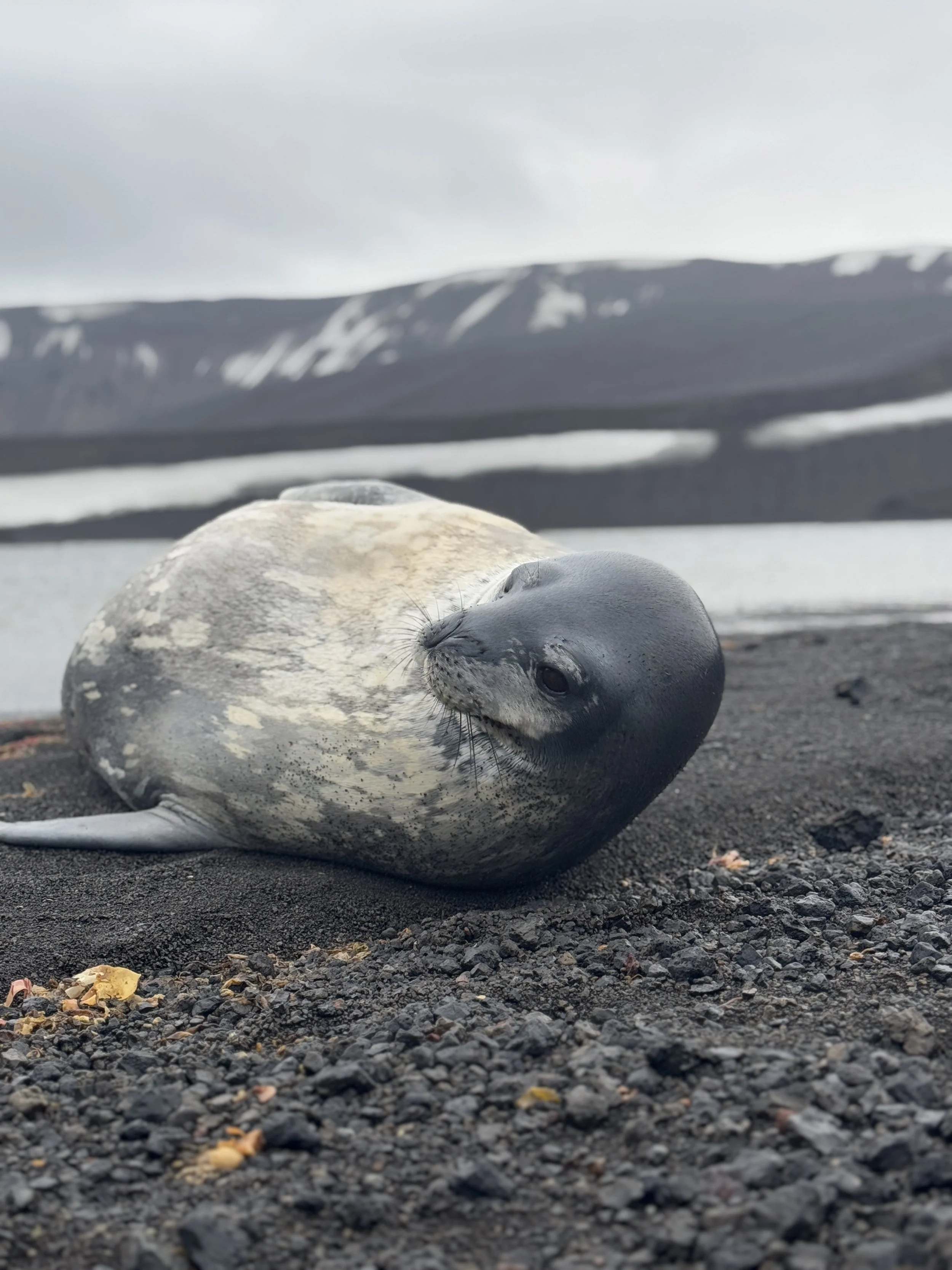
This group of islands are named after the Greek alphabet, which I loved because the symbol for Ohm (my last name) in physics is an Omega. So my first time setting foot on the White Continent was Omega Island. Fitting. There’s an Argentine research base at the entrance to this island group but we didn’t really see it until we were leaving and it’s tiny. There isn’t much to do here but it’s BEAUTIFUL and sheltered from weather, so it was a perfect spot to spend a week catching up on work and not being physically thrown around the boat after the drake passage. This was the best spot for Weddell seals. (I wish I had known this, as I would have spent a bit more time focusing on them, as I love seals and figured they’d be like this everywhere.)


It was also a great spot for climbing on icebergs (cruise ships probably won’t let you do this except in certain highly controlled settings) and generally getting acclimated. A few cruise ships sent Zodiacs (tenders/small boats/dinghies) through these islands, but not many. The groups that came through hiked to the top of Omega island, which I recommend. It can be a bit scary because the snowdrifts are deep, and I would ONLY DO THIS WITH A GUIDE. You don’t want to wander into a snowdrift that isn’t stable and you don’t want to end up in a crevasse or avalanche type of situation. BUT there is a path to the top of Omega Island where you can look over water and Anders Island and we saw a few whales/groups frolicking around when we were at the top. The perfect start to the trip.
Port Lockroy
The closest you’ll get to a “store” the entire time you’re down in Antarctica (aside from whatever your ship offers, if anything). Everything costs a lot—to buy a stuffed penguin is ~$100. In fairness, that also sponsors a penguin and the conservation efforts there… but it’s still a lot. I did buy some things—obviously, you have to!—but selection is limited. Mostly, I spent ~$200 to mail the postcards I had already made before I left. I got loads of compliments on these, from both other patrons, and the staff, and it was a fun personal touch. They took nearly two months to arrive, though, so bear that in mind.
The post office is just one part of Port Lockroy. For sailors, it’s actually a pretty small part, since the post office plans things with cruise ships, so it isn’t just “open” for regular folks to drop by. There’s also a fairly large gentoo penguin colony. This was our first real penguin encounter in Antarctica and my first two observations were: Penguins are LOUD and they SMELL. Guano has an odor. Usually there’s a breeze so you don’t notice it as much, or maybe you just get used to it, but be ready. Gentoos are also famously loud and it’s not really a sound you’d expect, it’s kind of a honk… like geese mixed with pigeons.


There’s a cove area behind the post office where sailboats will drop anchor, and you can do some hiking and exploring if your cabin fever gets too bad (spoiler, mine did). There’s also giant whale bones on one of the beaches and it’s in general just a cool gateway stop that can ease you into the crazy extremes of Antarctica.
Cuverville Island
When we left for Cuverville Island, we had high hopes of reaching the mainland (versus the islands). The easiest way to touchdown on the Graham peninsula is near the Gonzalez Videla Antarctic Base. Unfortunately, there was too much ice and it blocked our access. Still, this bit of sailing, known as Paradise Harbour, was one of the most gorgeous bits of sailing that we did, and it’s included on many cruise itineraries. We also saw several humpbacks throughout this trip, including one engaged in “tail slapping” where they try to confuse their pray by slapping their tails violently into the water. Funnily, there were also some penguins fishing in that same water (they eat the same small fish) who found the slapping disorienting and fled to a nearby iceberg.
Look out for: As cool as whales are, and as great as it is to see penguins on land… penguins in the water are truly surreal phenomenon. On land, a group of penguins is called a waddle. In the water, they’re called a raft. They look like a combination of fish and gnocchi, and they swim like dolphins, constantly leaping out of the water when they move in a group. It’s one of the funniest and most wonderful things you’ll ever see. (You can get a bit of the gist in the third photo below.)


Cuverville Island itself is home to the largest gentoo penguin colony in Antarctica and it is majestic to behold. It looks like the Port Lockroy colony until you start walking. You go over the first ridge… and there are still penguins as far as the eye can see. Keep walking to the next ridge? Same thing. We only spent a few hours here and it was one of the best days we had. Two big reasons:
1. We saw green. After weeks of rock and ice, seeing moss (GREEN!) was weirdly majestic. This might not be the case on a shorter trip, but color takes on a different dimension in the ice.
2. Penguins are phenomenal to just observe. I had so many people comment on my penguin photos, etc., and they were just iPhone photos. The key is to just sit at a safe distance and watch. They won’t be scared of you, so if you give it time, you’ll find magic moments. (Don’t get too close, follow the rules, and as a general rule with all wild animals, let them come to you versus the other way around.)


Keep in mind: Avian flu is a big concern. Cuverville island may or may not be open and access may or may not be restricted when you’re down there depending on circumstances. You’ll have to follow the best guidelines available (available being the key… remember, there’s no government oversight or regulation here, it’s an honor system based on rudimentary communication networks).
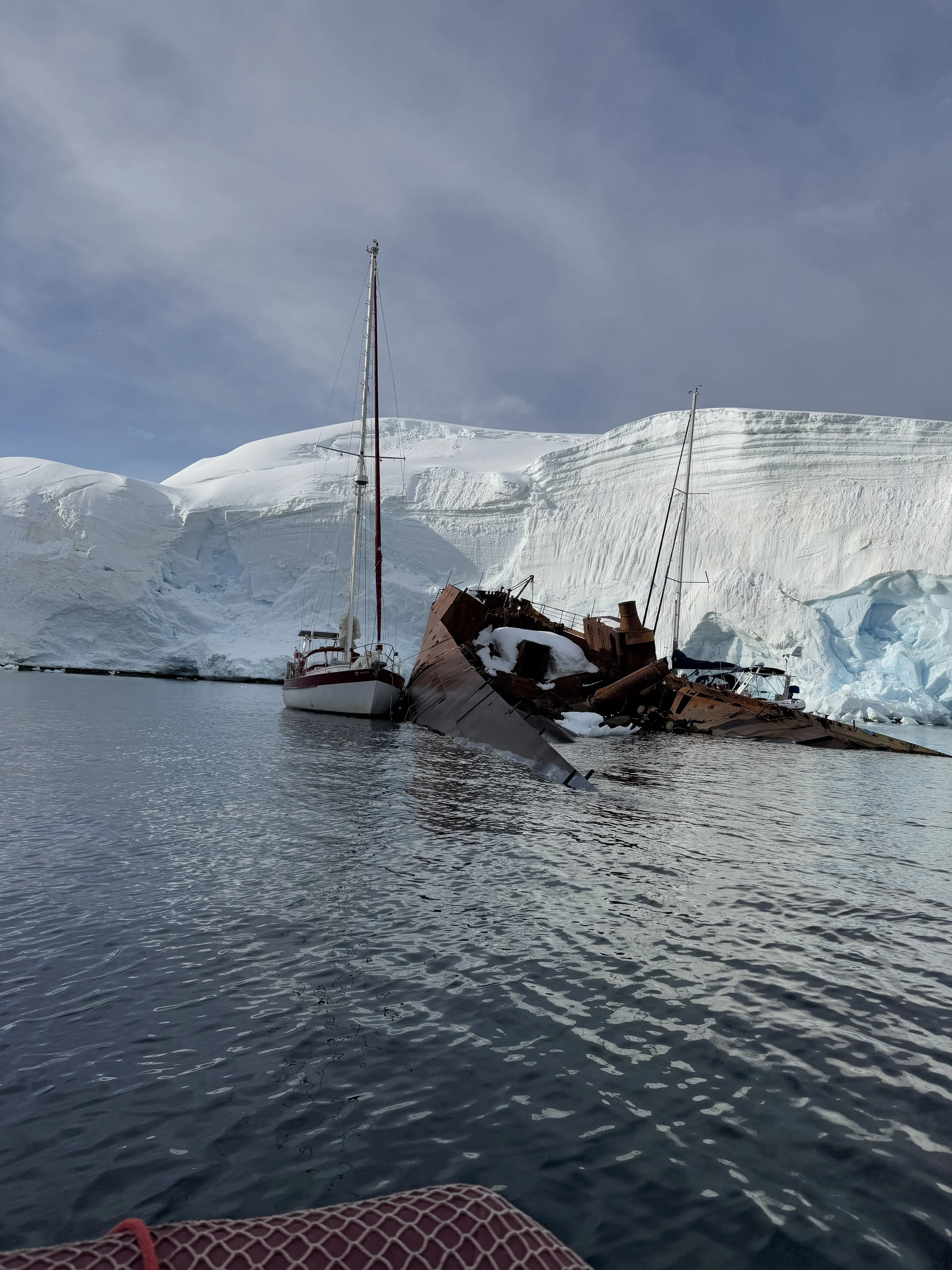
Enterprise Island and the Graham Peninsula
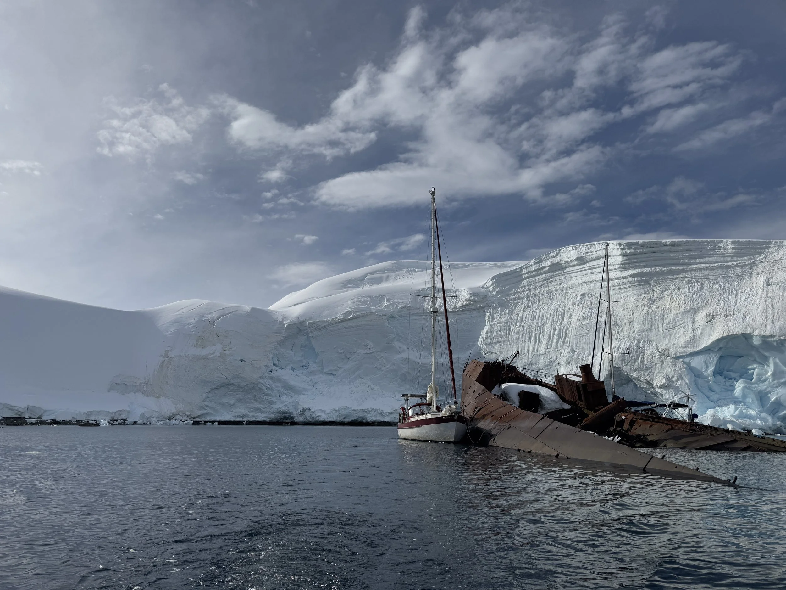
Imagine anchoring your sailboat to a sunken oil ship in crystal clear waters. That’s Enterprise Island. This wasn’t my favorite stop in Antarctica—the most exciting marine life was the tern population. But it was a treasure trove of marine history. Not only is the Enterprise a cool story (an oiler lit fire and grounded itself intentionally, no deaths, but you can see the skeleton of an oiling vessel), but there are several abandoned wooden boats sprinkled around the islands. It is nothing short of insane to see the boats that explorers used a century ago. If you think the conditions are tough on your ship… check out the vessels around Enterprise islands. There are also a few emergency buoy’s placed around here, which is a stark reminder of how very real the danger is if something goes wrong.
We also met a few other sailing vessels while anchored here and had dinner with the crew and guests on Selma—a crazy fast ship out of Poland. The comradery at sea is really magical if you’ve never experienced it (and I’m not just saying that because they gave me coffee for the first time in a month).
The other truly magical thing about Enterprise Island was that we finally made it to the mainland. We took the dinghy on a long (for us) 4-mile trip to the mainland, and because it was a random unplanned trip, it’s safe to say we were the only person to ever walk on this beach in Antarctica. I don’t envision most people will be able to recreate that experience, but if you ever get a chance, do it.


Deception Island
What we had earmarked as our first stop ended up being our last. Deception Island is so named because sailors of yore were deceived by it—it looked like solid block of rock from a distance, like any other island off the coast. In actuality, it’s a volcanic island shaped like a crater with a small entrance window that’s easy to miss. Once inside, you’re met with a strange place unlike anywhere else in Antarctica.
The mix of volcanic ash and snow/ice makes chunks of the coastline look like cookies and cream. Underwater vents create hot springs throughout a beach that’s otherwise filled with frigid waters. You can also see the ruins of whaling stations that were abandoned/destroyed during volcanic eruptions in the late 20th century. The World Heritage Foundation decided to leave the ruins as a testament to how Mother Nature can destroy manmade everything.


Must dos: See the ruins, hike near the entrance (it looks like Cabo or Positano, it’s wild). Cruise ships will block off a route, but there’s more hiking available. Swim in the hot springs. You can circle a few of the calderas. This is also one of the few places in Antarctica where you’ll really be able to walk/run/hike move around with real freedom, so take advantage of it.
The Falklands
We had to redirect to the Falklands because the Drake wasn’t playing ball with us, weather wise. It was a truly bizarre experience. For starters, it’s a British overseas territory (meaning it’s part of the UK) and it feels like it… but it also doesn’t. Mainly because there’s no internet. At least not the way we think of the internet. Once upon a time, the Islands signed an agreement with an internet provider and everything is metered—everyone on the island pays for their internet by the minute. There’s no streaming, very few places have websites, Facebook is still a primary tool for commerce… you get the drift.
That’s particularly bizarre when you realize that the main industry in the Falklands is tourism. Basically, the only way to do tourism in the Falklands is by organizing group adventures in advance. If you’re coming on land via a cruise ship, loads of tour operators will be there and you may be able to get great deals. But you can’t really explore things yourself (believe me, we tried). Most beaches are private land and require a permit, most things are only accessible by dirt roads, and the rental cars on the island aren’t allowed to go off pavement. This sort of makes sense—there’s only one commercial flight a week into and out of the Falklands (from Punta Arenas, the others are military flights to Oxford). Otherwise, all of the business comes from cruise ships (whose schedules depend on weather, because there’s no easy natural harbor/marina).
Must dos near Stanley: Yorke Bay and Gypsy Cove are a quick trip from Stanely if you have a vehicle, or a 90 minute walk each way if you’re feeling inspired. There’s a colony of Magallenic penguins, which were delightful to see. After Antarctica, it was weird to see penguins on sand and in grass. We encountered two lone king penguins. To be honest, they were a bit creepy looking—I’m convinced that the Penguin character in Batman is modeled on a King Penguin. For that (as well as a few other reasons, namely the really high cost) we made the call not to trek out to the big king colony. We didn’t get a chance to see any rockhopper penguins, either, which I was sad about. Finally, seals. I loved the Weddell seals in Antarctica. But many of the seals in the Falklands are elephant seals and, per the locals… are kind of mean. We didn’t encounter any seals here (which I’m glad about, I can keep my seals are adorable narrative alive)… but something to keep in mind if you do!
For souvenirs—The Wool Shed has the best sweaters and scarves! They’re made in South America but its Falklands wool. Styles are limited but quality is nice; I plan to wear mine as a staple for a long time. For homemade wool things, like socks, mittens, and the WARMEST sheepskin slippers you’ll ever find, made by hand and affordably priced—The Little Harbour Gift Shop is your best bet, but selection is limited. Most of the gift shops sell imported things with a handful of local stuff… and there aren’t that many shops.


Keep in mind: You’ll see LOADS of Chinese fishing trawlers. If you follow international affairs, you may have read about the Chinese fishing industry and how it operates, particularly in arctic waters. You’ll see that play out here. If you want to hear a captain go on a rant, ask them about their encounters with Chinese fishing trawlers.
Tips for enjoying Antarctica
Pick the right boat
Your experience will depend entirely on the boat you choose. It determines your comfort while you travel, your itinerary, the crew, the food, everything. Itinerary is important. As is comfort. Try to keep your expectations in check, though. One fancy sailboat we saw had a washer/dryer on board. Another limited guest showers to one every three days because their desalination tool wasn’t working. As much as you’re going to want creature comforts when you’re paying that much (I would, too), try to remember that the conditions are extreme.
Do the expeditions
I’m recommending this because you’ll have the most fun if you get off the boat and explore. But I’m also recommending it because expeditions tend to be first off the boat, so you’re more likely to get places before the animals get shy or the snow gets trampled and so on. From my understanding, many ships have different expedition options, like scuba or marine life. But if it were me, I’d be saying yes anytime someone asked me if I wanted to get in a zodiac and explore.
Don’t mess around with faulty gear
A few years ago, I was hiking in Utah and my gear started leaking. I was wading through 50° water, it wasn’t that cold out, and I didn’t want to spend the several hours going back to get new gear (or worse, miss the hike all together). I ended up with gnarly hypothermia. Magnify that by 20, and you’ll start to understand why I say don’t mess with faulty gear in Antarctica. When we hiked up Omega Island, I got snow in my boots that I didn’t get out. It melted. On the dinghy back to the boat, it had started to refreeze. It’s hard to describe the pain I experienced waiting for my toes to thaw. It’s not the first time I’ve had early-stage frost bite, so I knew what I was dealing with, and how far to push it, but I really don’t recommend it. The same thing happened to David and since he has actual frostbite on his toes (leftover from his days mountaineering) he didn’t realize it was happening until his feet started hurting every day for the next two weeks.
The same goes for boats and even people. Small problems can easily get magnified into big problems somewhere like Antarctica. I’m not saying don’t take risk (if you’ve read this far, you know that) but you need to be very aware of worst-case scenarios and plan Bs and Cs when assessing your risk tolerance.
Take a polar plunge
I have never been a polar plunge person. I am always cold, I’ve gotten hypothermia before, and I have Raynauds, so I’m particularly susceptible to cold trauma. Which I share only so that you know where I’m coming from when I tell you the water in Antarctica is a balmy 38° and you should absolutely jump in at least once. It will give you a new appreciation for Titanic. But you’re only there once, and it’s not that bad. The cold is temporary, and you’ll be able to warm up afterwards. Plus, you’ll have something to lord over all of the annoying tech bros who talk about the benefits of cold showers and chryo chambers. I plunged three times, and the third time stayed in for 10 seconds just to prove I could.
Take too many pictures
Yes, they might all look the same. But when it comes to penguins or seals or whatever else, it’s hard to predict which shot will be THE shot. Plus, you can always delete things later. Most of us will never be back in Antarctica again.
I’m also a big fan of filming or clicking away automatically without paying attention. Why? Because I want to live in the moment. I’d rather take way too many pictures that I’m only half paying attention to than focus all of my energy on getting the right photo… and miss what I’m experiencing in real time. That said, don’t be the person who enjoys things in real time and forgets to take pictures. If a seal comes up to say hi to you on a beach in deception island and you’re two feet apart and your buddy “forgets” to take a picture, it’s always going to eat at you a little bit.
Specific questions about things I wrote about (or didn’t write about)? Comment!